
Hi,
I have experienced a problem when using radar points in the dataset v.1.0-mini. I obtained radar points using RadarPointCloud.from_file_multisweep with the parameters given below:
chan = ”RADAR_FRONT”,
sample_rec = radar_sample_record
ref_chan = ”CAM_FRONT”,
nsweeps: = 1,
min_distance = 1.
Then, I projected those radar points onto the current frame using the function view_points from nuscenes.utils.geometry_utils . I also checked the pixel coordinates as you did after the projection.
The following figure shows us the first frame (sample) of the scene-0655 with token of ‘5991fad3280c4f84b331536c32001a04’ together with the bounding box of the vehicle with the token of ‘b6ded29415ae4ad2b76f0bf73fb674ce’, its projected center denoted by the green circle, and some radar points projected onto that vehicle denoted by the blue stars.
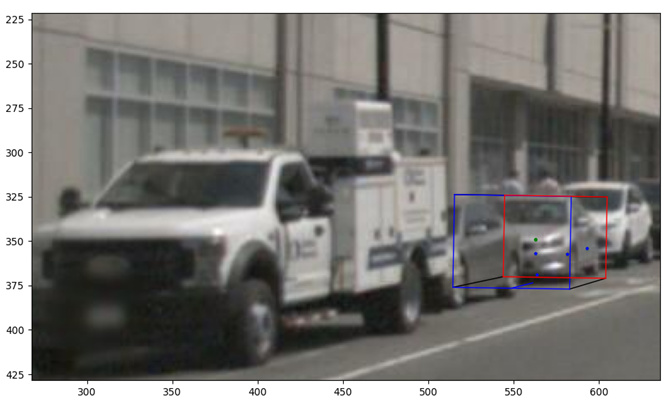
Using the box object the center of the vehicle is given by
box center = [-8.09666314, 0.88561165, 38.43211491]
However, the radar depths are so different from the depth of the object (z=38.43 in the reference coordinate system). Those four radar points on the image, their depths and pixel coordinates are
radar_depths = [36.0257, 53.669502, 55.486626, 62.085667]
radar_pixel_coordinates = [[563.4879 , 581.2913 , 562.82794, 592.8059 ],
[368.91064, 357.32034, 356.7815 , 354.03317]].
I could not figure out why the radar points except the one deviates too much from the position of the vehicle. For close objects, for example, the truck in the same frame, the radar depths are close to the truck’s center. I thought that the error can arise from multi-path. Then, the radar is not a reliable sensor to detect distant objects in your dataset. Actually, radar detections can results in disastrous results according to the detection of that vehicle (car) above. In addition, I used the default filters when obtaining the radar detections. They are valid and the probability of being FA is less than 25%:
p1 = array([-7.56566865e+00, 1.40690779e+00, 3.60257001e+01, 1.00000000e+00,
3.40000000e+01, 1.55000000e+01, -7.50000000e+00, -5.00000000e-01,
-1.63710788e-02, -3.90016916e-03, 1.00000000e+00, 3.00000000e+00,
1.90000000e+01, 1.90000000e+01, 0.00000000e+00, 1.00000000e+00,
1.60000000e+01, 3.00000000e+00])
p2 = array([-1.05083155e+01, 1.59943066e+00, 5.36695010e+01, 3.00000000e+00,
4.70000000e+01, 3.50000000e+00, -7.50000000e+00, -5.00000000e-01,
-8.13871715e-03, -1.78231602e-03, 1.00000000e+00, 3.00000000e+00,
2.00000000e+01, 2.00000000e+01, 0.00000000e+00, 1.00000000e+00,
1.60000000e+01, 3.00000000e+00])
p3 = array([-1.16818392e+01, 1.62971787e+00, 5.54866238e+01, 1.00000000e+00,
4.90000000e+01, 1.15000000e+01, -7.50000000e+00, -5.00000000e-01,
-1.46069797e-02, -3.41923651e-03, 1.00000000e+00, 3.00000000e+00,
1.90000000e+01, 1.90000000e+01, 0.00000000e+00, 1.00000000e+00,
1.60000000e+01, 3.00000000e+00])
p4 = array([-1.15855462e+01, 1.68734258e+00, 6.20856682e+01, 1.00000000e+00,
5.80000000e+01, 1.25000000e+01, -7.50000000e+00, -7.50000000e-01,
-5.34341782e-02, -1.11321202e-02, 1.00000000e+00, 3.00000000e+00,
1.90000000e+01, 1.90000000e+01, 0.00000000e+00, 1.00000000e+00,
1.60000000e+01, 3.00000000e+00])
Could you please explain to me why the radar detections deviate from the ground truth value (center of the bbox) too much?
Thank you,