Convert traffic lights locations from global coordinates system to camera coordinate system

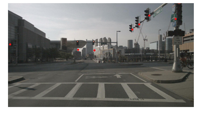
I want to convert coordinates of traffic lights into camera coordinates system but I was not able to do that. I used similar code to the function used to convert from point could to the camera but when I draw the points on the image, I found that they are not accurate. Could you please help me to figure out what is wrong with my code?
Here is my code:

import os
import json
import random
from typing import Dict, List, Tuple, Optional, Union

import descartes
from tqdm import tqdm
import numpy as np
import matplotlib.pyplot as plt
import matplotlib.gridspec as gridspec
from matplotlib.patches import Rectangle, Arrow
from matplotlib.axes import Axes
from matplotlib.figure import Figure
from mpl_toolkits.axes_grid1.inset_locator import mark_inset
from PIL import Image
from shapely.geometry import Polygon, MultiPolygon, LineString, Point, box
from shapely import affinity
import cv2
from pyquaternion import Quaternion

from nuscenes.nuscenes import NuScenes
from nuscenes.utils.geometry_utils import view_points

from nuscenes.nuscenes import NuScenes
nusc = NuScenes(version=‘v1.0-mini’, verbose=False,dataroot=’/s/red/a/nobackup/vision/nuScenes/data/sets/nuscenes’)
camera_channel = ‘CAM_FRONT’
patch_radius=50
sample_record = nusc.get(‘sample’, sample_token)
scene_record = nusc.get(‘scene’, sample_record[‘scene_token’])
log_record = nusc.get(‘log’, scene_record[‘log_token’])
log_location = log_record[‘location’]
nusc_map = NuScenesMap(dataroot=’/s/red/a/nobackup/vision/nuScenes/data/sets/nuscenes’, map_name=log_location)

cam_token = sample_record[‘data’][camera_channel]
cam_record = nusc.get(‘sample_data’, cam_token)
cam_path = nusc.get_sample_data_path(cam_token)
im = Image.open(cam_path)
im_size = im.size
cs_record = nusc.get(‘calibrated_sensor’, cam_record[‘calibrated_sensor_token’])
cam_intrinsic = np.array(cs_record[‘camera_intrinsic’])
layer_names = [‘traffic_light’]

cam_token = sample_record[‘data’][camera_channel]
cam_record = nusc.get(‘sample_data’, cam_token)
cam_path = nusc.get_sample_data_path(cam_token)
im = Image.open(cam_path)
im_size = im.size
cs_record = nusc.get(‘calibrated_sensor’, cam_record[‘calibrated_sensor_token’])
cam_intrinsic = np.array(cs_record[‘camera_intrinsic’])

Retrieve the current map.

poserecord = nusc.get(‘ego_pose’, cam_record[‘ego_pose_token’])
ego_pose = poserecord[‘translation’]
box_coords = (
ego_pose[0] - patch_radius,
ego_pose[1] - patch_radius,
ego_pose[0] + patch_radius,
ego_pose[1] + patch_radius,
)
records_in_patch = nusc_map.get_records_in_patch(box_coords, layer_names, ‘intersect’)

Init axes.

fig = plt.figure(figsize=(9, 16))
ax = fig.add_axes([0, 0, 1, 1])
ax.set_xlim(0, im_size[0])
ax.set_ylim(0, im_size[1])
ax.imshow(im)
near_plane = 1e-8

Retrieve and render each record.

for layer_name in layer_names:
for token in records_in_patch[layer_name]:
record = nusc_map.get(layer_name, token)

    line = nusc_map.extract_line(record['line_token'])
    if line.is_empty:  # Skip lines without nodes
        continue
    xs, ys = line.xy
    points=np.array([[record['pose']['tx']],[record['pose']['ty']],[record['pose']['tz']]])
    # Transform into the ego vehicle frame for the timestamp of the image.
    points = points - np.array(poserecord['translation']).reshape((-1, 1))
    points = np.dot(Quaternion(poserecord['rotation']).rotation_matrix.T, points)

    # Transform into the camera.
    points = points - np.array(cs_record['translation']).reshape((-1, 1))
    points = np.dot(Quaternion(cs_record['rotation']).rotation_matrix.T, points)

    # Remove points that are partially behind the camera.
    depths = points[2, :]
    
    behind = depths < near_plane
    if np.all(behind):
        continue

    # Grab the depths before performing the projection (z axis points away from the camera).
    depths1 = points[2, :]
   
    # Take the actual picture (matrix multiplication with camera-matrix + renormalization).
    points = view_points(points[:3,:], cam_intrinsic, normalize=True)
    depths = points[2, :]

print(points)

    # Skip polygons where all points are outside the image.
    # Leave a margin of 1 pixel for aesthetic reasons.
    inside = np.ones(depths.shape[0], dtype=bool)
    inside = np.logical_and(inside, points[0, :] > 1)
    inside = np.logical_and(inside, points[0, :] < im.size[0] - 1)
    inside = np.logical_and(inside, points[1, :] > 1)
    inside = np.logical_and(inside, points[1, :] < im.size[1] - 1)

    if np.any(np.logical_not(inside)):
        continue

    points = points[:2, :]

    plt.scatter(points[0], points[1], c=nusc_map.explorer.color_map['walkway'], s=70)

Display the image.

plt.axis(‘off’)
ax.invert_yaxis()

Here are some example of the plots:

Dear @mohamed_chaabane. I believe what you are doing is correct. However, our localization only models the yaw angle of the ego vehicle, but not pitch and roll. This intersection is particularly tricky as it seems to have a minor slope. I also saw this when creating this video: https://youtu.be/wUBdMrnL6BU?t=8
Besides the missing pitch and roll, any localization algorithm will have minor errors, so it’s probably best to model these uncertainties.

Thanks a lot ! That make sense. Is there by any chance the list of scenes that have this localization error so that I can avoid them?
Thanks,

You can find a list of scenes where the localization is (slightly) off the road at https://github.com/nutonomy/nuscenes-devkit/blob/master/python-sdk/nuscenes/map_expansion/map_api.py#L945
In general our localization is pretty good. Most of the errors come from a mismatch between localization coordinates and map. We published only a single version of each map, when the data was actually collected with dozens of different map versions. However, we deemed it unfeasible to publish dozens of near-copies of the map.

Hi @holger-motional,

I am trying to align satellite imagery from Google and HD maps, as described in this post https://forum.nuscenes.org/t/aligning-hd-map-with-satellite-imagery-from-google/212?u=harish_rithish.

I observe misalignment between aerial imagery and HD maps. The amount of misalignment seems to be the same for all samples from a particular scene. However, the amount of misalignment between samples from different scenes are different. I suspect that this could be because of different versions of the map.

So, could you kindly share the list of scenes that were created together. Example:
Map 1: scene 1, scene 2 …
Map 2: scene 25, scene 26 …

Thanks in adcance :slight_smile:

Please read my answer on the other post first.
Regarding the scene mapping, multiple scenes can come from the same log and the maps don’t change within a log. The table below shows which log maps to which code version. So you will know that for all the scenes for e.g. map8 nothing changed.

Log name Map version
n008-2018-05-21-11-06-59-0400 map1
n008-2018-07-26-12-13-50-0400 map2
n008-2018-07-27-12-07-38-0400 map2
n008-2018-08-01-15-16-36-0400 map2
n008-2018-08-01-15-34-25-0400 map2
n008-2018-08-01-15-52-19-0400 map2
n008-2018-08-01-16-03-27-0400 map2
n008-2018-08-06-15-06-32-0400 map3
n008-2018-08-21-11-53-44-0400 map4
n008-2018-08-22-15-53-49-0400 map4
n008-2018-08-22-16-06-57-0400 map4
n008-2018-08-27-11-48-51-0400 map5
n008-2018-08-28-13-40-50-0400 map6
n008-2018-08-28-15-47-40-0400 map6
n008-2018-08-28-16-05-27-0400 map6
n008-2018-08-28-16-16-48-0400 map6
n008-2018-08-28-16-43-51-0400 map6
n008-2018-08-28-16-57-39-0400 map6
n008-2018-08-29-16-04-13-0400 map6
n008-2018-08-30-10-33-52-0400 map6
n008-2018-08-30-15-16-55-0400 map6
n008-2018-08-30-15-31-50-0400 map6
n008-2018-08-30-15-52-26-0400 map6
n008-2018-08-31-11-19-57-0400 map6
n008-2018-08-31-11-37-23-0400 map6
n008-2018-08-31-11-56-46-0400 map6
n008-2018-08-31-12-15-24-0400 map6
n008-2018-09-18-12-07-26-0400 map7
n008-2018-09-18-12-53-31-0400 map7
n008-2018-09-18-13-10-39-0400 map7
n008-2018-09-18-13-41-50-0400 map7
n008-2018-09-18-14-18-33-0400 map7
n008-2018-09-18-14-35-12-0400 map7
n008-2018-09-18-14-43-59-0400 map7
n008-2018-09-18-14-54-39-0400 map7
n008-2018-09-18-15-12-01-0400 map7
n008-2018-09-18-15-26-58-0400 map7
n015-2018-07-11-11-54-16+0800 map8
n015-2018-07-16-11-49-16+0800 map8
n015-2018-07-18-11-07-57+0800 map8
n015-2018-07-18-11-18-34+0800 map8
n015-2018-07-18-11-41-49+0800 map8
n015-2018-07-18-11-50-34+0800 map8
n015-2018-07-24-10-42-41+0800 map9
n015-2018-07-24-11-03-52+0800 map9
n015-2018-07-24-11-13-19+0800 map9
n015-2018-07-24-11-22-45+0800 map9
n015-2018-07-25-16-15-50+0800 map10
n015-2018-07-27-11-24-31+0800 map11
n015-2018-07-27-11-36-48+0800 map11
n015-2018-08-01-15-10-21+0800 map12
n015-2018-08-01-16-32-59+0800 map2
n015-2018-08-01-16-41-59+0800 map2
n015-2018-08-01-16-54-05+0800 map2
n015-2018-08-01-17-04-15+0800 map2
n015-2018-08-01-17-13-57+0800 map2
n015-2018-08-02-17-16-37+0800 map2
n015-2018-08-02-17-28-51+0800 map2
n015-2018-08-03-12-54-49+0800 map13
n015-2018-08-03-15-00-36+0800 map2
n015-2018-08-03-15-21-40+0800 map2
n015-2018-08-03-15-31-50+0800 map2
n015-2018-09-25-11-10-38+0800 map14
n015-2018-09-25-13-17-43+0800 map14
n015-2018-09-26-11-17-24+0800 map15
n015-2018-09-27-15-33-17+0800 map16
n015-2018-10-02-10-50-40+0800 map16
n015-2018-10-02-10-56-37+0800 map16
n015-2018-10-02-11-11-43+0800 map16
n015-2018-10-02-11-23-23+0800 map16
n015-2018-10-08-15-36-50+0800 map16
n015-2018-10-08-15-44-23+0800 map16
n015-2018-10-08-15-52-24+0800 map16
n015-2018-10-08-16-03-24+0800 map16
n015-2018-11-14-18-57-54+0800 map16
n015-2018-11-14-19-09-14+0800 map16
n015-2018-11-14-19-21-41+0800 map16
n015-2018-11-14-19-45-36+0800 map16
n015-2018-11-14-19-52-02+0800 map16
n015-2018-11-21-19-11-29+0800 map16
n015-2018-11-21-19-21-35+0800 map16
n015-2018-11-21-19-38-26+0800 map16
n015-2018-11-21-19-58-31+0800 map16

Thank you for providing the details. Apart from rubbersheeting, let me also see if I am able to use this information to align better.