I am trying to get LiDAR pointcloud project to image only for the annotated (box) items, with the below code. But an error of getting all zeros after masking. It would be helpful if you can give some hints.
(lidar_xyz_points, lidar_z_points , image)=NuScenesExplorer.map_pointcloud_to_image(NuScenesExplorer(nusc), pointsensor_token=lidar_pointsensor_token, camera_token=camera_token, min_dist=1.0)
    #pointcloud <np.float: 2, n)>, coloring <np.float: n>, image=NuScenesExplorer.map_pointcloud_to_image()

    lidar_xyz_points[2]=lidar_z_points # add z points (depth) to the main array.

       boxes = nusc.get_boxes(lidar_nusc_sample_data['token'])
       lidar_gt_mask = np.zeros(lidar_xyz_points.shape[-1])
       for box in boxes:
               ##### Check if points are inside box #####
               cur_mask = nuscenes.utils.geometry_utils.points_in_box(box, lidar_xyz_points)
               lidar_gt_mask = np.logical_or(lidar_gt_mask, cur_mask)
       lidar_gt_mask = np.clip(lidar_gt_mask, a_min=0, a_max=1)
       lidar_xyz_points = np.compress(lidar_gt_mask, lidar_xyz_points, axis=-1)
I also tried to have the box using "boxes = nusc.get_boxes(camera_nusc_sample_data[‘token’]) ", but same issue of all zeros.
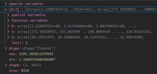
An Example data of lidar_xyz_points (with z points) is shown below.
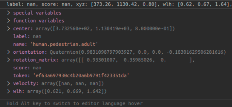
An example of one box is shown below